The early 17th Century was a time of great turbulence in our society, but also of continuity. Most importantly to us, it was a time of diligent record keeping which we can access today to understand better where we have come from. From the licence to distil whiskey in 1608 to the statistics which even then oiled the wheels of government, we can recognise our modern world in the records of 400 years ago.
Fundamental to ‘place’ is (or was) the townland – confusing to outsiders (and now many of us locals) this unit of land has been in use for centuries, from the 12th-century land grants of mediaeval monasteries to the line on your domestic rates bill today. Until the mid-20th century (and much later in some localities), rural addresses were given exclusively by townland and the road names and numbers we use today were meaningless to country dwellers. Small enough to be personal in scale but significant enough for government use, townlands stood the test of time until the processing power of computers and our increasingly mobile and urbanised society brought in postcodes and an increasing number of administrative divisions adrift from our history.
This publication maps all 16,000 townlands in the 9 counties of Ulster and the administrative units of church and state into which they have been organised. In an attractive and easily understood layout, these units are shown in the context of land ownership in the 17th century, a pattern clearly recognisable until a century ago when the Land Purchase Acts broke up the estates and facilitated tenant farmers buying their own land. By using the maps and index, family and local historians can easily grasp the essentials of our ancestors’ lives – where they worked, paid their rent, went to church and market, etc.
This is an essential reference guide for both newcomer and serious researcher, showing exact locations and where to look for related records. This material has never been collated for the entire province before.
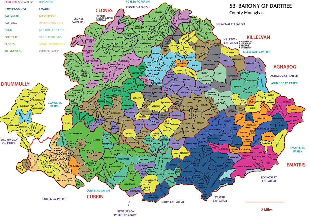 These are arranged by Barony (portion of a county) to give the widest coverage on a readable scale. As well as townlands the maps show civil, Church of Ireland and Roman Catholic parish boundaries and the relevant estate from the Plantation era.
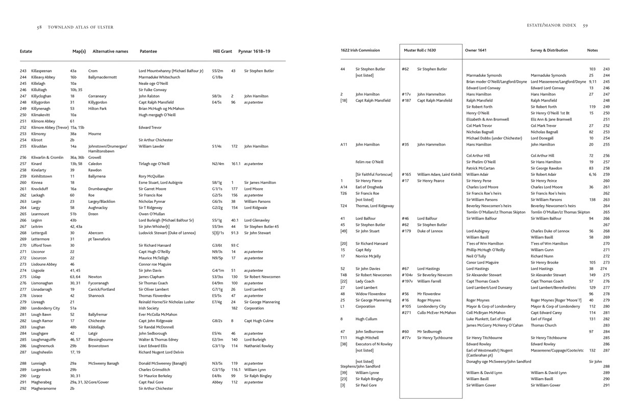 This is an extract from the index of Landed Estates showing the change of ownership for each during the C17th, with more details under the notes which follow. This can be very helpful in identifying potential places of origin for settlers by analogy to where their landlords came from. This is even the case where Irish landlords obtained estates remote from their ancestral lands (e.g. O'Neill of The Fews came from Dungannon). Names and titles of the landowning family can also help find deeds relating to the property where other details are not indexed.
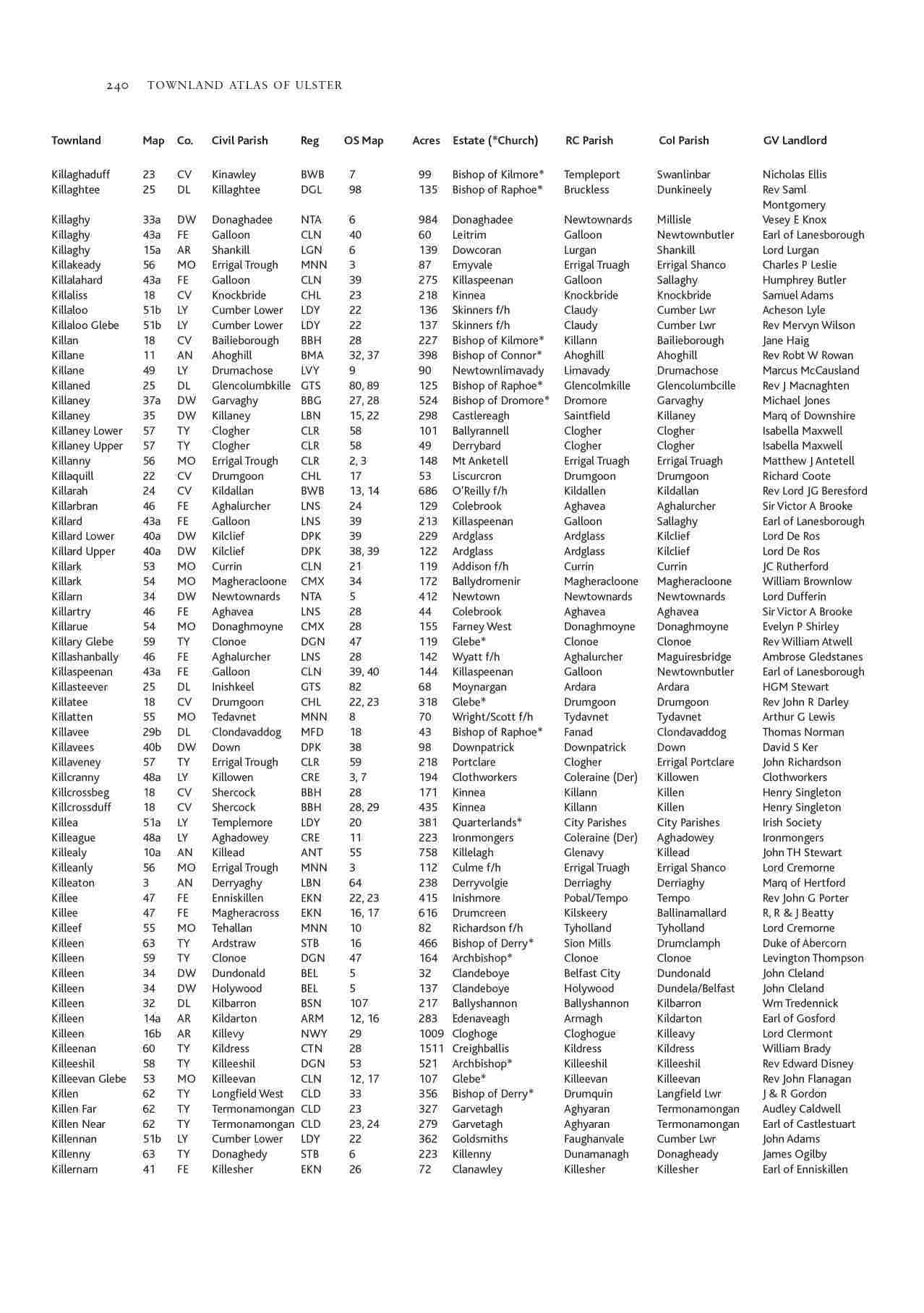 This index lists all 16,000+ townlands with details such as OS map sheet, civil registration district and Griffith Valuation landlord opening up a wide range of sources for further research.
Read what others are saying about the Townland Atlas of Ulster
Today, as Ireland becomes increasingly urbanised and new housing estates proliferate, authentic townland names are in danger of disappearing. A wonderful book such as this is, therefore, invaluable in maintaining a record of a rich shared heritage and a culture, north and south, that speaks to everyone.
Prof. Terence Dooley, Maynooth University Department of History
“The design of such an ambitious undertaking has been undertaken with consummate care, skill and deftness and contributes significantly to a work which not only shows researchers the precise location of their areas of interest but also suggests other primary sources and their location that may well help them develop their search.”
Trevor Parkhill, editor Familia: Ulster Genealogical Review
To have mapped and provided such comprehensive detail for each of Ulster's 16,000 townlands is an achievement that will stand the test of time. It (the Townland Atlas of Ulster) will or should become a standard reference book for those people tracing their Ulster roots. I now know that if I'm seeking a visual representation of townlands, parishes and estates in a particular area I will be straight to your maps; and if seeking, for a particular townland, details of church registers (CoI and RC) and 17th and 19th century landlords my first port of call will be the Index of Townlands.
Brian Mitchell, Derry Genealogy
I received the Townland Atlas of Ulster this morning and am delighted with it. The quality of the book is exceptional and the content fascinating. As someone who is fascinated by maps, and loves the townlands where I grew up in County Down, it unexpectedly made me feel quite emotional to see them memorialised so beautifully. It will certainly be a big help to my research, especially as I pursue DNA matches who relate to my unknown great grandfather in County Antrim, territory unfamiliar to me. I just wanted to congratulate everyone on its production and of course particular thanks go to Andrew Kane.
Lyn from Encinitas
What a marvellous resource it is! Please congratulate Andrew. I’ll be using it all the time as my (never-ending) Irish research continues.
Michele from NSW
The beautiful atlas has arrived. It is a magnificent publication.
Ann from Canberra
I received my pre-ordered copy today and must say it's an incredible piece of work to have. A great reference book.
Well done to all involved !!!
Paddy from Gweedore
A magnificent achievement - I look forward to delving into the vast array of resources beautifully arranged and presented.
Larry from Maynooth
My copy of the Townland Atlas of Ulster arrived safely yesterday. To say that I am thrilled with it is an understatement. It's a wonderful book with superb production values, packed with information. I probably will not get much work done this weekend as I explore it in more detail.
Angela from Dublin